Combined sewer overflows (CSOs) are relief points in sewer systems that carry sewage and stormwater in the same pipe. When heavy rains fill the pipes, CSOs release sewage and stormwater into local water bodies to prevent sewage backups into homes and businesses. King County is committed to CSO control: meeting the state standard of reducing the number of overflows at each of our CSOs to no more than one per year over a long-term average. Our investments in CSO control, industrial waste permitting, and source control to date have resulted in improvements in sediment quality near most CSO outfalls.

The Sediment Management Plan looked at sediment quality at all of King County’s CSOs and identified strategies to address those where persistent contaminants continue to pose a potential risk to aquatic life, wildlife, or human health. The data summarized in the Sediment Management Plan suggests that controlled King County CSOs will not contribute to pollution problems in Puget Sound or local waters. In addition, sediment near some uncontrolled CSOs already meets Sediment Management Standards set by the Washington State Department of Ecology and do not need further cleanup.
Assessment of sediment quality at King County CSOs
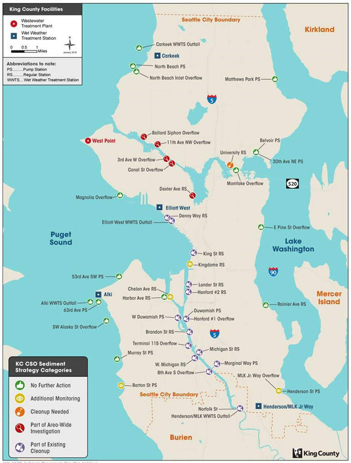
We are continuing to investigate conditions at several CSO outfalls with known sediment quality issues, as shown on the map below. We need to further investigate some CSO locations to confirm whether they are or are not causing sediment pollution.

Source: Sediment Management Plan Update Fact Sheet, Fall 2018
Map on webpage has been revised October 2021. North Beach Inlet Overflow is now listed as "No further action."
No further action needed

The sediment at these CSO outfalls meet all state sediment standards and cleanup is not necessary. These areas fall into two categories, where no cleanup was necessary and where sediment cleanup at the CSO outfall is complete. The CSOs are mostly located in the King County shorelines of Puget Sound and Lake Washington.
No cleanup necessary
-
53rd Ave. SW Pump Station Overflow
-
63rd Ave. SW Overflow
-
Alki Outfall
-
Belvoir Pump Station and 30th Ave. NE Overflow.
-
Carkeek Outfall
-
E Pine St. Pump Station Overflow
-
Harbor Ave. Regulator Station Overflow
-
Matthews Park Pump Station Overflow
-
Montlake Regulator Station Overflow
-
Murray St. Pump Station Overflow
-
North Beach Pump Station Wet Weather Overflow
-
North Beach Pump Station Inlet Overflow
-
Rainier Ave. Pump Station Overflow
-
S Magnolia Overflow
-
SW Alaska St. Overflow
Cleanup completed
Duwamish/Diagonal - These two share the same outfall location and this area was identified in the original Sediment Management Plan as needing cleanup.
-
Hanford #1 Overflow
-
Duwamish Pump Station Overflow
Norfolk St. - These two share the same outfall location and this area was identified in the original Sediment Management Plan as needing cleanup.
-
Norfolk Regulator Station Outfall
-
MLK Wet Weather Treatment Plant Overflow
Pier 53-55 Sediment Cap and Enhanced Natural Recovery Area Remediation Project - Several agencies jointly conducted this demonstration project to test innovative sediment capping and thin layer placement methods.
Additional study or monitoring needed

Further studies are needed to determine if there are sediment quality concerns at these CSO outfall locations. At these CSOs, the data does not show the need for cleanup, but modeling suggests we keep an eye on them for possible problems.
-
Barton St. Pump Station Overflow
-
Kingdome Regulator Station Overflow
-
MLK Regulator Station/Henderson Pump Station Overflow*
*A report with monitoring data is expected in late 2022.
Additional studies and monitoring conducted that investigated sediment quality and helped determine the sediment strategy at these CSOs. Once the necessary sediment strategy is determined, CSOs are removed from Additional Monitoring and moved to the appropriate strategy.
-
Ballard Siphon Overflow
-
North Beach Pump Station Inlet Overflow
-
Lake Washington (Belvoir/30th, E. Pine, Rainier, Matthews, MLK/Henderson) Overflows
Part of an area wide clean up

These five CSO outfalls are located in the Lake Washington Ship Canal and Lake Union next to urbanized areas with a mix of commercial and industrial development. As a result, the sediments at these locations are impacted from multiple sources of contamination. In addition, the contamination is widespread from the constant vessel traffic resuspending and distributing it. Therefore, cleanup of small areas at these CSOs are likely to become re-contaminated unless the entire area is addressed. Such large scale actions are led by EPA or Ecology.
Ship Canal/Lake Union
-
Ballard Siphon Overflow
-
3rd Ave. W Overflow
-
Canal St. Overflow
-
11th Ave. NW Overflow
-
Dexter Ave. Regulator Station Overflow
Part of an existing cleanup

These CSO sites are part of an existing cleanup.
Lower Duwamish Superfund Site – these outfalls will be cleaned up as a part of the ongoing cleanup of the Lower Duwamish Waterway through the Superfund program. Of these areas, sediments at the Brandon St. Regulator Station Overflow were identified in the original Sediment Management Plan as needing cleanup, but a separate cleanup will not be necessary as it will be addressed as part of the Superfund site cleanup.
-
W Duwamish Overflow
-
Terminal 115 Overflow
-
S Michigan St. Regulator Station Overflow
-
W Michigan St. Regulator Station Overflow
-
E Marginal Way Pump Station Overflow
-
8th Ave. S Overflow
East Waterway Superfund Site – These two areas will be cleaned up as a part of the East Waterway Superfund cleanup. They were both identified in the original Sediment Management Plan as needing cleanup.
Denny Way Sediment Remediation Project – This area was identified in the original Sediment Management Plan as needing cleanup. We are conducting this cleanup in three steps. The first two steps, capping and removal of contaminated sediment, are complete. The third, an investigation to determine if any further cleanup is needed, is ongoing.
 Translate
