 Translate
Pump Station Revetment Repair
Community engagement
All public, tribal, and partner comments and suggestions are welcome to help inform the design of the revetment improvement project. The project team will be at local events and visiting the neighborhood over the next year to hear from you. You can also reach out directly to the project contact at any time with questions or comments.
Project overview
The King County Flood Control District, together with King County as service provider, is planning to make improvements to the damaged Pump Station Revetment on the left bank of the Snoqualmie River, directly upstream of Meadowbrook Bridge. Improving the revetment will help prevent potential erosion damage to sanitary sewer infrastructure and the historic Meadowbrook Bridge.
The project is located in the City of Snoqualmie along the left bank of the Snoqualmie River at river mile 40.3, directly upstream of the Meadowbrook Bridge and at the dead-end of SE Walnut Street.
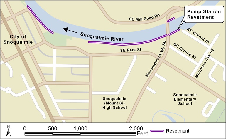
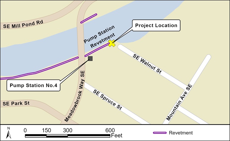
Project location, looking downstream towards Meadowbrook Bridge. Project site is on the left bank.
Project update
The King County Flood Control District selected a project alternative for the Pump Station Revetment Repair. The repair will extend the revetment further upstream and incorporate wood and rock to provide long-term protection to the City of Snoqualmie’s sewer lift station and Meadowbrook Bridge. The revetment was damaged further during the December 2025 Flood. King County, working as a service provider to the District, is beginning more detailed design and welcomes your input.
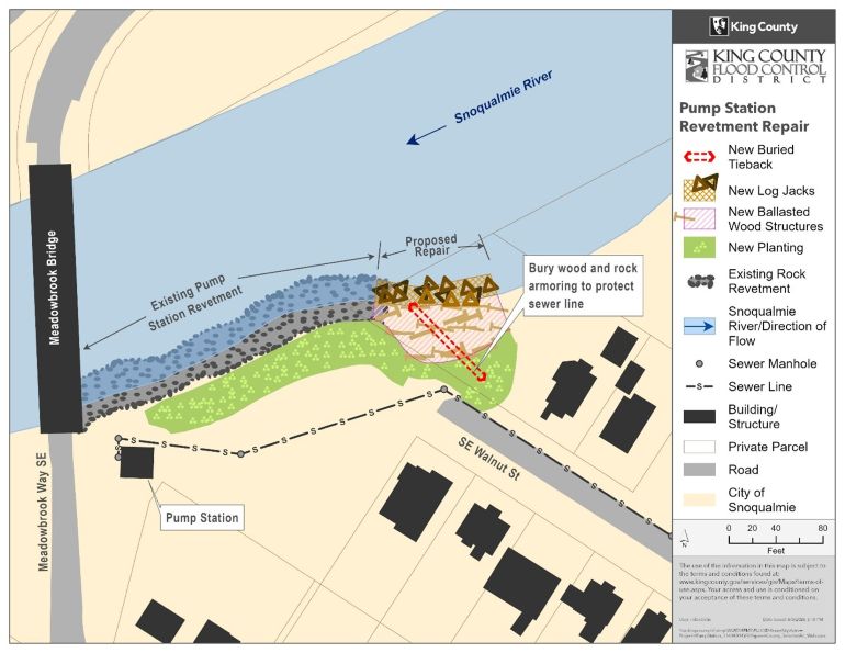
The project includes a rock revetment which is buried and ends in high ground, rock and wood armoring along the shoreline and native plant landscaping. It will result in a less steep bank which reduces the need for future repairs and less erosion upstream.
Channel erosion study complete
To better understand what is causing changes to the riverbanks in this project area, the project completed the Snoqualmie River Three Forks to Falls Geomorphic study in February 2025 to understand impacts to the river from changes made to Snoqualmie Falls from 2004 to 2012. In the 2016 Snoqualmie River Hydraulic Study, King County found that lowering the Snoqualmie Falls diversion weir and widening of the channel upstream of the Falls dropped flood levels by 1.5 feet during a 100-year flood (1% annual exceedance probability) at the Falls. These changes lowered the depth of flooding and the number of flood events in the City of Snoqualmie. Study results are now being used to guide the design of the Pump Station repair.Revetments are structures built along a riverbank to reduce erosion, usually built with rocks, wood, plants, and other materials. Although they limit bank erosion from river channel migration, revetments do not prevent flooding. There are many resources available to reduce flood risks and increased flood preparedness, at kingcounty.gov/prepareforflooding.
What is a weir?
Weirs are human-made or naturally occurring structures across a river. They can change the river’s water level height to allow diversion of water for power generation. The first weir was build across the Snoqualmie River, above the Falls, in 1898.
What is Annual Exceedance Probability (AEP)?
AEP is the chance, or probability, that flooding at a particular extent or level might occur or be exceeded in any given year. When you see 50% AEP, it means that there is a 50% chance that flooding at that level will occur or be exceeded in any given year. This used to be described as a '2-year-flood', but since that sounds like the flood level would occur every two years, we no longer use that reference.
Project goals
- Provide protection to City of Snoqualmie sanitary lift station and historic Meadowbrook Bridge.
- Design revetment improvements to be compatible with ongoing and anticipated channel evolution.
- Balance long-term revetment duration with minimizing environmental harm, reflecting community input and reduced lifecycle costs.
- Engage with interested parties throughout the project lifecycle.
Project design
The King County Flood Control District selected an alternative in February 2026. The selected alternative incorporates wood and rock in the upstream portion of the revetment to minimize future damage as well as erosion of the upstream bank. Native trees and shrubs will be planted around the revetment. The selected alternative balances long-term public infrastructure protection, minimizes environmental impact, and incorporates community input, especially on swimmer and boater safety and efficient use of public funds.
Project schedule (subject to change)
| Dates | Activity |
|---|---|
| Q1 2025 | Geographic study completed |
| Q4 2024 – Q3 2028 | Community engagement |
| Q1 2026 | Alternative selection |
| Q1 2027 | 30% design complete |
| 2028 | Construction |
| 2028 - 2032 | Effectiveness monitoring |
Construction impacts
Project construction is currently scheduled for Summer or Fall 2028. There will be little or no impact to neighbors until construction begins. King County will work to reduce noise, dust, and traffic impacts on SE Walnut Street during construction.
King County is working to limit the impacts of construction. Construction may temporarily impact use of roads, sidewalks, trails, and parks in the area.
We will update this webpage with impacts to roads, sidewalks, trails, or parks in the area as the project moves through design and permitting. We will also post signs and flyers near the project site and notify local businesses and residents before and during construction. To receive updates, please sign up for the project email list.