
 Translate
North Mercer Island/Enatai sewer upgrade
The North Mercer Island/Enatai Sewer Upgrade Project will replace aging pipes serving areas in North Mercer Island and Bellevue near Enatai Beach, and the Town of Beaux Arts Village.
Project description
King County is replacing sewer pipes that serve areas in North Mercer Island, the southwest portion of Bellevue near Enatai Beach Park, and the Town of Beaux Arts Village. This pipeline carries wastewater from the North Mercer Island Pump Station to the Sweyolocken Pump Station in Bellevue. Once installed, the new pipes will provide sewer service for 50 years or more. To learn more about the project overall, including what we are building, construction information, and what to expect, view our StoryMap.
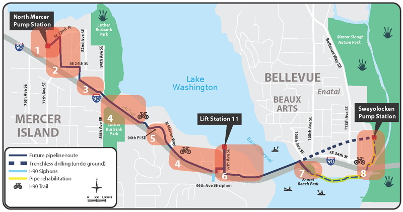
To meet community needs, we broke the project up into 8 project areas, shown on the map. We provide updates about specific areas depending on where work is taking place.
General project updates
October 20, 2026
Project-wide updates
Mercer Slough Connector Trail reopened
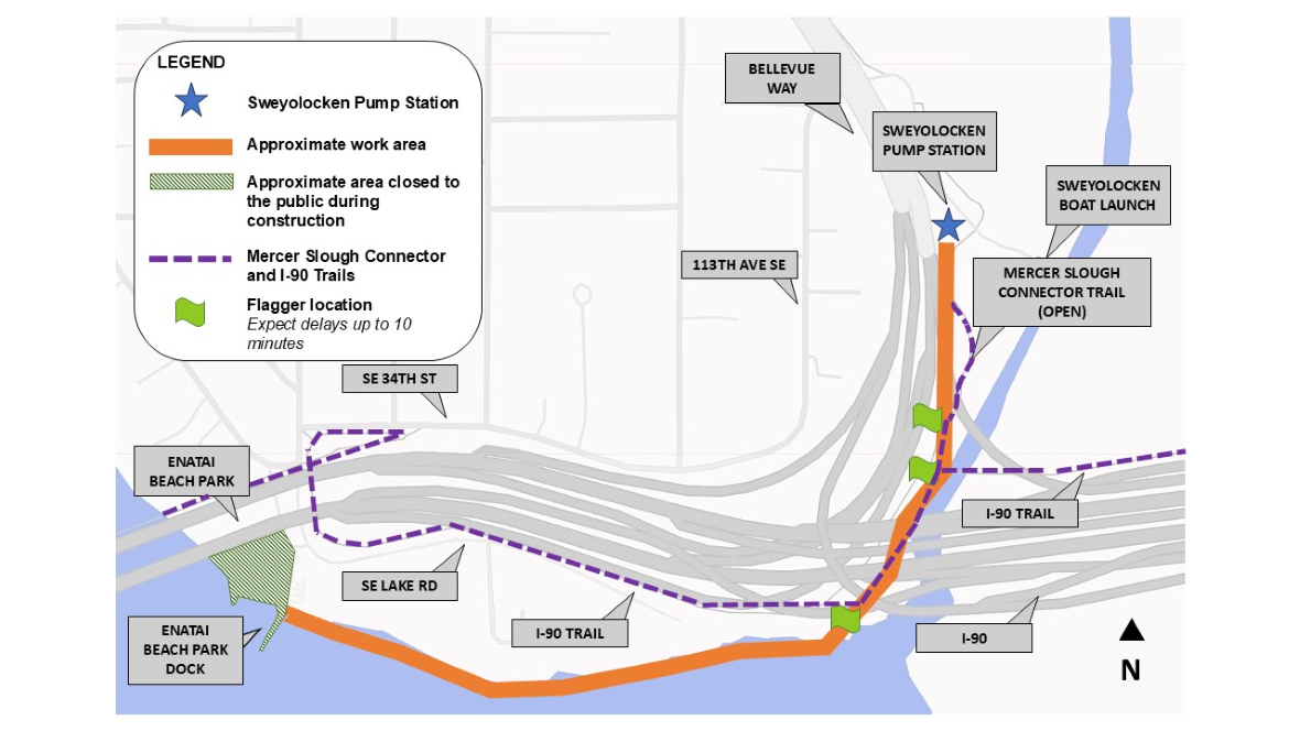
The Mercer Slough Connector Trail reopened on October 20. Construction is ongoing 24 hours a day, 7 days a week, and flaggers are stationed at three locations to guide people walking and biking through the active work area.
Trail users should expect delays of up to 10 minutes while crews move construction vehicles, equipment, and materials.
Please travel slowly and follow all posted signs, traffic control signals, and crew instructions.
Construction activity in Mercer Island*
Area 1. North Mercer Pump Station: Crews are continuing restoration work at the North Mercer Pump Station. Expect noise, vibrations, and occasional traffic delays as equipment enters and leaves the site. For more information, please review our May Area 1 notification.
Area 2. North-central Mercer residential streets: Final paving on SE 22nd St, 78th Ave SE, SE 24th Street, and 81st Ave is complete. For more information, check past Area 2 updates.
Area 3. North Mercer Way: no updates.
Area 4. I-90 Trail: The I-90 Trail between 84th Avenue Southeast and Shorewood Drive is open.
Crews have started restoration work on the last closed section of the I-90 trail between Southeast 35th Street/North Mercer Way and Southeast 35th Place/East Mercer Way. Once the remaining pipe work on SE 36th St is complete and the trail is fully paved and restored, this final section of the I-90 trail will reopen. For more information, please review our June Area 6 notification. Trail users should follow the posted detour route during construction:
- Trail detour map between S.E. 35th St and S.E. 35th Pl. This takes trail users on East Mercer Way, Southeast 36th Street, and North Mercer Way, before connecting back to the I-90 Trail. Drivers, please drive slowly and watch for cyclists on the roadway.
For more information, check past Area 4 updates.
Area 5. 90th Pl S.E.: Crews are continuing restoration and testing of the odor control unit in the cul-de-sac at the top of 90th Place Southeast. Crews will return to pave a small area behind the odor control unit during the next permitted paving window, which begins in Mid-March. For more information, check past Area 5 updates.
Area 6. NE Mercer Island:
Fruitland Landing: Crews completed substantial work at the north access point for the 96th Avenue Siphon and are now beginning demobilization. Expect noise while the vacuum truck is in use and short delays when traveling through the area. Demobilization is expected to continue through August. For more information, please review our June Area 6 notification.
S.E. 36th St near City Hall: Crews are now completing the final phase of work for the I‑90 Crossing sewer pipe upgrade at the south access point near Mercer Island City Hall and along the section of the I-90 trail between Southeast 35th Street and Southeast 35th Place. This work includes sidewalk and curb restoration, removal of the temporary pedestrian detour, roadway paving, trail paving, and final landscaping. For more information, please review our September Area 6 notification.
S.E. 35th Pl: Restoration continues on Southeast 35th Place.
For more information, check past Area 6 updates.
Luther Burbank Park: King County’s contractor has moved construction equipment out of the back half of the South Parking Lot at Luther Burbank Park. The full parking lot is open for community use.
Construction activity in Bellevue*
Area 7. Enatai Beach Park: Beginning as early as October 5, King County’s contractor will begin preparation work to reline the existing pipe along the Bellevue shoreline between Enatai Beach Park and Sweyolocken Boat Launch. The swim beach, boathouse, playground, and dock at Enatai Beach Park will be closed to the public during construction. For more information, check out our October Area 7 notice.
Area 8. Sweyolocken/Mercer Slough: The Mercer Slough Connector Trail has reopened. Construction is active 24 hours a day, 7 days a week, as crews continue sewer pipe relining between Sweyolocken Boat Launch and Enatai Beach Park. Flaggers are stationed at three locations along the trail to direct people walking and biking through the work zone.
Trail users should expect delays of up to 10 minutes when construction vehicles and equipment are moving through the area. Please travel slowly and follow all signs, traffic control devices, and instructions from crews. For more information, check out our October Area 8 notice.
* Construction schedules can change based on factors such as site conditions, weather, and material availability. Please check this website for updates.
Construction status

This map is updated as construction progresses across north Mercer Island and southwest Bellevue. It shows areas of planned construction, active construction, and post-construction restoration.
If you need this map in another format, please leave a voicemail on the project hotline at 425-305-3578 or call TTY Relay 7-1-1. Reasonable accommodations are available to you for free.
Map current as of February 1, 2025
Previous general project updates
- King County responds to wastewater overflow on Mercer Island, February 2026
- Extended Saturday work hours on north Mercer Island through December 2025, August 2025
- Extended Saturday work hours 7 a.m. to 7 p.m. on north Mercer Island approved to continue through March 2025, December 2024
- Extended Saturday work hours in parts of the project area as early as June 29 through August, June 2024
- Hard work and big progress in 2023, and more to come in 2024!, SPRING 2024
- Newsletter - Sewer construction has been progressing for a year, Spring 2023
- Updated Bike Detour Map available, February 2023
- Enatai Siphon pipe installation is complete! December 19, 2022
- See you at the Mercer Island Farmers Market! August 17, 2022
- Construction schedules often change – check our website for the most up to date information! August 12, 2022
- Summer newsletter available online, check your mailbox or nearby flyer box! July 26, 2022
- Newsletter - Major sewer construction activities continue this summer and fall in Mercer Island and Bellevue, July 2022
- Watch out! Cycling in a construction zone is dangerous! Proceed with caution to keep us all safe! July 22, 2022
- The construction hotline is back in service; meet us at the Mercer Island Farmers Market this weekend! June 14, 2022
- The North Mercer Island/Enatai construction hotline is down. Please use our temporary hotline number. June 9, 2022
- Construction work on the I-90 trail will begin as early as June 8, June 2, 2022
- Surveying continues/utility locates beginning in May, May 4, 2022
- Construction equipment and activity coming to Mercer Island Boat Launch, April 22, 2022
- Visit our pre-construction online StoryMap, April 6, 2022
- Sewer construction starts this spring! March 2022
- Sewer construction starting soon! March 2, 2022
- Newsletter - Sewer construction starts this spring! March 2022
- Newsletter - Construction Ahead, April 2021
- Construction Reference Guide, April 2021
- Utility work on SE 35th Place between E. Mercer Way and Briarwood Lane planned for early February, January 25, 2021
- Utility work on 78th Avenue Southeast planned for late December 2020, December 14, 2020
- Utility work on 90th Place Southeast planned for late November 2020, November 23, 2020
- Field investigations starting as early as April 22 near Mercer Island Boat Launch and Enatai Beach Park, April 21, 2020
- Field investigations near Sweyolocken Pump Station starting as early as January 9, January 7, 2020
- Tree and site survey along I-90 Trail and North Mercer Way starting as early as December 9, December 6, 2019
- Fieldwork at Luther Burbank Park starting as early as May 20, May 17, 2019
- Fieldwork at Mercer Island Boat Launch starting as early as May 20, May 17, 2019
- Construction and restoration on the I-90 Trail, Spring 2019
- Join us at Bike Everywhere Day on May 17! May 10, 2019
- Tree survey near I-90 Trail and North Mercer Pump Station starting as early as April 22, April 19, 2019
- Newsletter, March 2019
- Field investigations starting as early as March 4 in Enatai Beach Park and Sweyolocken Pump Station, March 1, 2019
- Utility locates, potholing, and surveying in North Mercer Island beginning as early as January 3, December 28, 2018
- Field investigations starting as early as December 3 near Bellevue shoreline, Enatai Beach Park and Sweyolocken Pump Station, November 20, 2018
- Tree survey work beginning November 5, October 30, 2018
- In-water fieldwork along Bellevue shoreline starting July 18, July 16, 2018
- Join us at Bike Everywhere Day on May 18!
- Field investigations starting as early as April 16 on Mercer Island, April 10, 2018
- Field investigations starting as early as April 12 in Enatai Beach Park and Mercer Slough, April 10, 2018
- Field investigations next to I-90 Trail and on SE 35th Place starting on Wednesday, April 4, April 2, 2018
- The online open house is live! Stop by to review the detailed sewer upgrade route, March 1, 2018
- Field investigations starting as early as January 24 in Mercer Island and Bellevue, January 22, 2018
- Survey work on Mercer Island January 8-12; Expect delays along North Mercer Way, January 3, 2018
- Potholing to locate underground utilities is underway. Expect delays along North Mercer Way. December 15, 2017
- Fact sheet: Keeping sewage flowing during construction (Grinder Pumps), November 2017
- Sewer route details come into focus, July 2017
- Survey notification, July 2017
- In-water survey work near Enatai Beach Park and Mercer Island Boat Launch starting June 21, June 15, 2017
- Fact sheet: Installing King County’s new sewer pipeline in North Mercer Island/Enatai, April 2017
- Newsletter, January 2017
- Post card: Join us for an upcoming community meeting (January 25 and 26), January 11, 2017
- Soil sampling resumes on Mercer Island starting November 30, November 23, 2016
- Final alignment decision expected by year’s end, November 15, 2016
- Soil sampling on 96th and 97th avenues southeast starting as early as Tuesday, November 1, October 28, 2016
- Soil sampling starting as early as Thursday, October 27, October 21, 2016
- Survey work begins on Mercer Island September 19, September 16, 2016
- Early design for King County’s North Mercer Island and Enatai Sewer Upgrade Project, August 2016
- Field investigations move into the East Channel week of August 8, August 3, 2016
- Field investigation update and changing of the guard, August 1, 2016
- Geotechnical work to begin in Bellevue, Week of July 11, 2016, July 5, 2016
- King County begins field investigations at North Mercer Island and Southwest Bellevue in June 2016, June 1, 2016
- North Mercer Island/Enatai sewer upgrade newsletter, Summer 2015
- King County continues field investigations in your neighborhood April 20, April 15, 2015
- King County continues field investigations in your neighborhood April 13, April 8, 2015