
 Translate
16th Avenue SW: SW 100th Street to SW 107th Street Pedestrian Safety Improvements & Traffic Calming Project
The final phase of construction began January 2026

April 2026: Contractor crews working for King County are installing rapid flashing beacons on 16th Ave SW and SW 106th Street. When someone presses the button, the lights flash to let drivers know a pedestrian is crossing.
Status update
April 14, 2026
Construction is underway to complete installation of rectangular rapid flashing beacons, intended to alert drivers to crossing pedestrians, and complete the remaining roadway striping. Striping will be completed during non-peak daytime hours, between 8:30 am and 4 pm. This work may be rescheduled due to machine, crew, or equipment availability or weather.
Crews also plan to install ten additional modern ADA curb ramps in 2026. Locations of these curb ramps are below.
- 16th Ave SW and SW 102nd St (two corners)
- 16th Ave SW and SW 100th St (four corners)
- 16th Ave SW and SW White Center Cutoff (one corner)
For the most up to date information on Road Services work, please visit our MyCommute map. We’ll also email or text a Road Alert to you if you’ve registered for that service.
Project map
The yellow part of the map shows where 16th Ave SW was repaved and restriped between SW 100th St and SW 107th St. This helps slow down traffic and make the street safer for people walking. The orange dotted lines show two other areas we paved in summer 2025, SW 100th St and White Center Cutoff SW. We are not adding bike lanes or any other changes there.
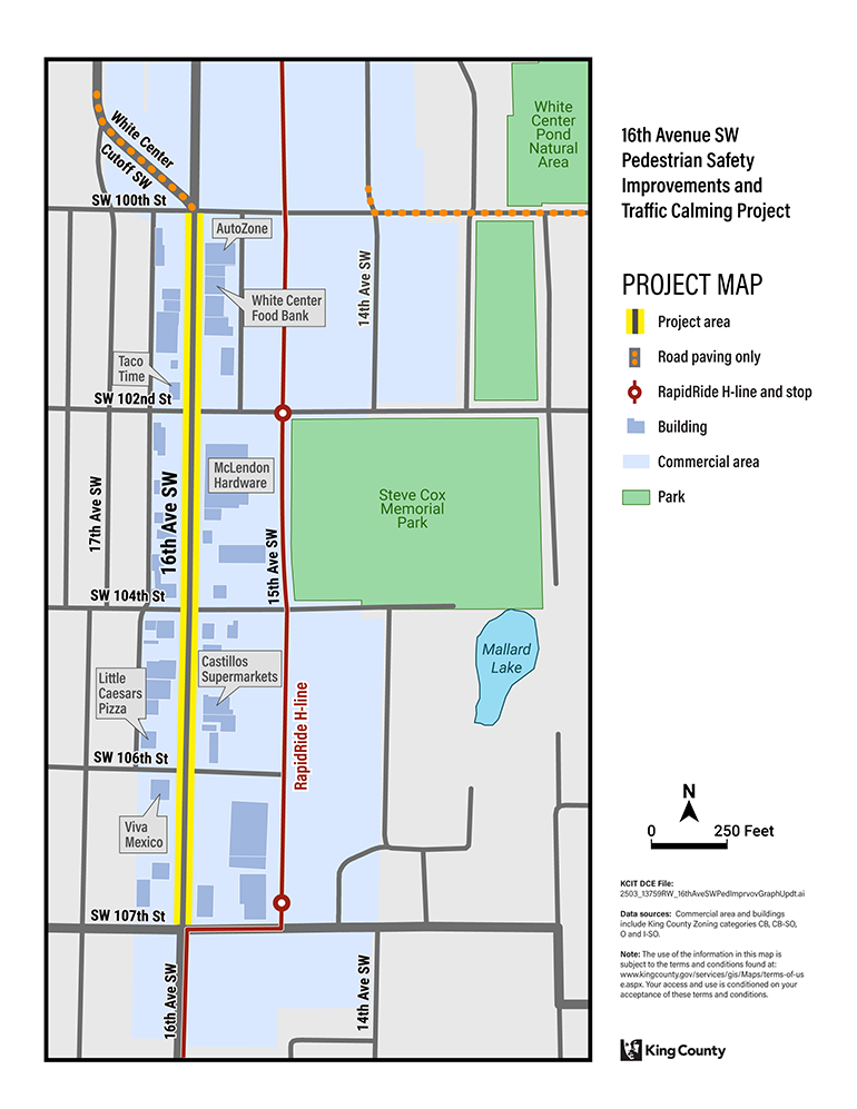
View larger image of the map (157KB)
Safety improvements coming to 16th Avenue SW
Higher speeds can result in more collisions with pedestrians.
Roads with a single travel lane in each direction and a center turn lane have slower, calmer traffic. This is important for pedestrians and cyclists because slower vehicle speeds make it safer, reducing the risk of injury and death.
- Fewer travel lanes make it safer to cross the street and allow room for sidewalk curb extensions and buffered bicycle lanes.
- Sidewalk curb extensions reduce the crossing distance for pedestrians in the crosswalk.
- Extra space, or buffer zone, on both sides of the bicycle lane provides a dedicated place for non-motorized traffic.
This project will calm traffic and improve pedestrian safety by providing the following:
-
One lane in each direction
This helps prevent speeding by slowing down traffic and makes crossings safer for people walking. -
Center turn lane
Provides a safer place for drivers to make left turns. This allows traffic to move freely in the main travel lane. -
Sidewalk curb extensions at SW 104th Street and SW 106th Street intersections
There are no traffic signals at these two intersections to stop traffic. Sidewalk curb extensions will help drivers see people walking in the crosswalk. The extensions also will shorten the distance people need to cross. - ADA curb ramps at all four corners of the intersections of 16th Ave SW and SW 100th St and SW 102nd Streets.
Modern ADA curb ramps make it safer to move between sidewalks and streets by reducing trip hazards and creating smooth crossings. They also include textured warning surfaces and gentle slopes that help people using wheelchairs, strollers, or other mobility aids cross more safely. -
Rapid flashing lights and new pedestrian crossing signs at intersections that do not have a traffic signal
Flashing lights and high-visibility signs will alert drivers when pedestrians are crossing 16th Avenue SW at SW 104th and SW 106th Street. - Bicycle lanes in both directions
New, five-foot (5-foot) wide bicycle lanes will separate bike riders from motor vehicle traffic. This will give people on bikes or other active transportation more room so that they don’t have to share the road with cars. - Two feet of extra space (buffer zone) on both sides of bike lane
Cyclists feel more comfortable and secure when they are not too close to moving traffic or parked cars. A two-foot (2-foot) wide buffer zone on both sides of the bike lane could help encourage more people to choose biking or other types of active transportation to get to where they want to go.

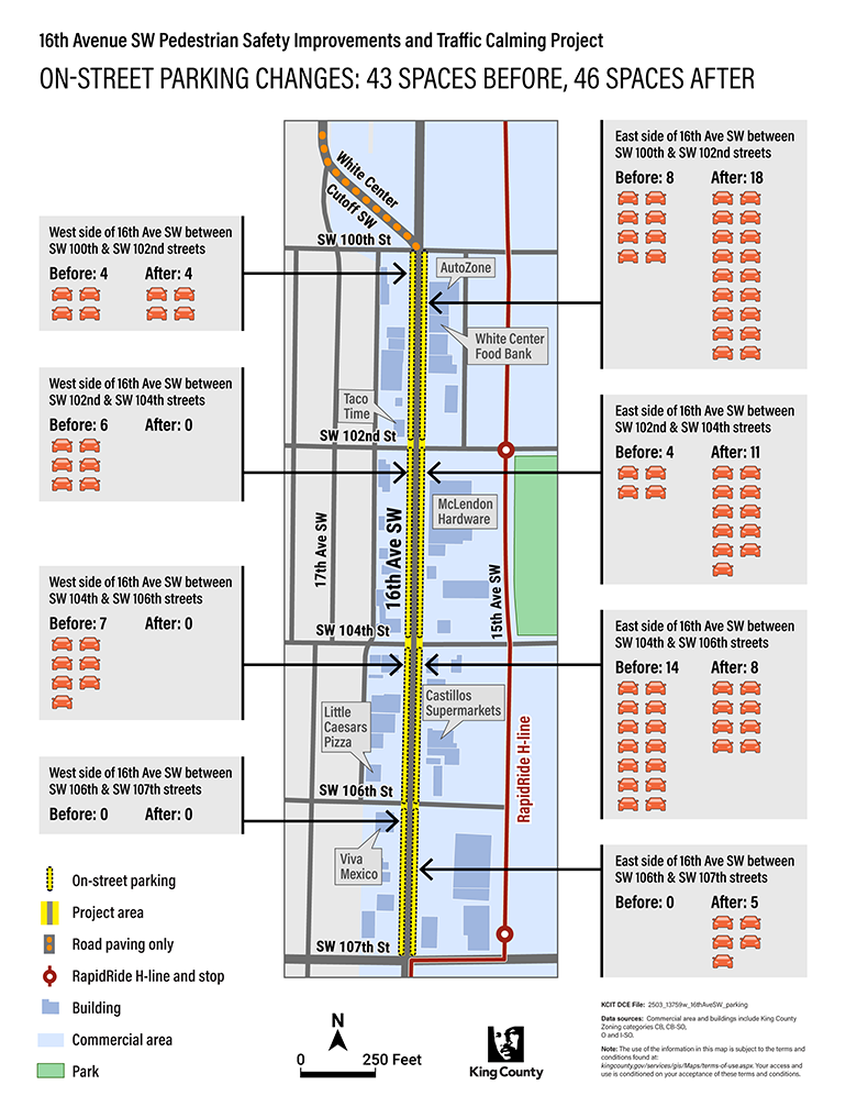
Parking changes
Currently, there are 43 parking spaces on 16th Avenue SW between SW 100th and SW 107th streets. The total number of parking spaces in the project area will increase to 46, but some will be in different places than before. For instance, some parking spaces that are currently located on the west side of the road will be moved to the east side. This shift is necessary to accommodate new bike lanes, sidewalk curb extensions, and safety improvements.

Striping and parking between SW 107th and SW 106th St. View larger (8MB)

Striping and parking between SW 106th St and SW 104th St. View larger (8MB)
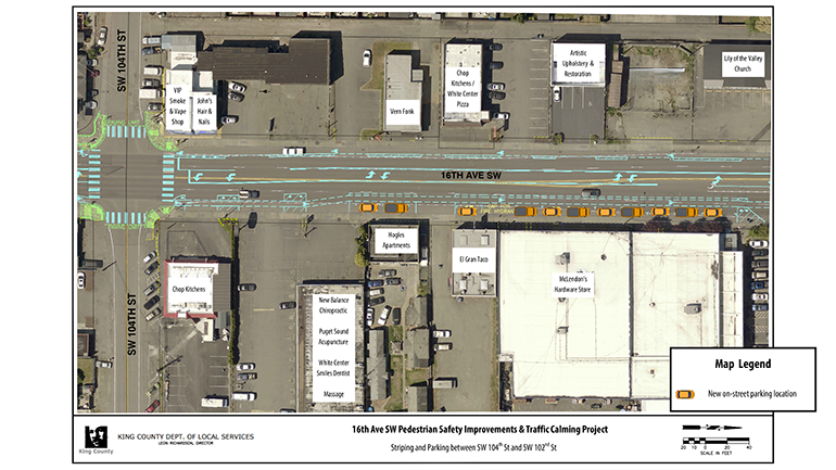
Striping and parking between SW 104th St and SW 102nd St. View larger (8MB)

Striping and parking between 102nd St and SW 100th St. View larger (8MB)
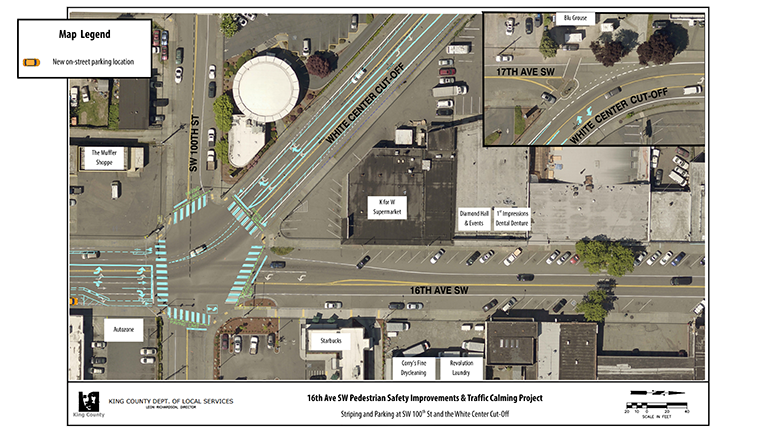
Striping and parking at SW 100th St and White Center Cut-Off. View larger (8MB)
View PDF with all combined striping and parking maps (32MB)
What to expect during phase 3 of the project
Daytime Road work on 16th Ave SW: Began in January 2026
Now that paving is done, crews have returned to finish other safety improvements. Work will happen Monday through Friday during the day. Here’s what to expect.
Work dates:
- This phase began on January 12, 2026. Work is temporarily paused as crews wait for materials needed to complete the work. The project resumed on April 13, 2026. The project could be delayed if there is bad weather or equipment breakdowns.
Work hours:
- Crews will work from 7 am to 5 pm each weekday.
Noise:
- You may hear noise from construction equipment like trucks, generators, grinders, and rollers.
Parking:
- Street parking will be limited during active construction. Crews will reopen parking spots as soon as they finish in each area.
Sidewalks:
- Most of the work will happen in the road, but some sidewalks may close for short periods. Signs will show where to walk safely.
Access to businesses and homes:
- Crews may block driveways for short periods. They will work quickly to reopen access.
Dust:
- Some dust is normal during road work. Crews will use water and other tools to keep it down.
Garbage and mail:
- We don’t expect any changes to garbage pickup or mail delivery. These services will be notified about the work.
What We’re Doing to Help:
- Crews will work efficiently to finish the project as quickly as possible.
- We’ll post regular updates on this website to keep you informed.
- Have concerns or questions? Contact us anytime at AskLocalServices@kingcounty.gov or 206-477-3800.
We appreciate your patience while we improve the road and make it safer for pedestrians.
Project timeline
- Fall 2021: Preliminary design complete
- Spring 2022: Initial public outreach and comment period complete
- Winter 2024: Final design complete
- 2022 through 2025: Ongoing public outreach
- March/April 2025: Drainage pipe replacement on SW 104th St (between 15th Ave SW and 17th Ave SW) View project flyer (750 KB)
- July/August 2025: Road was paved and temporary lane striping was applied
- January to May 2026: Bike lanes in each direction, curb extensions, permanent lane striping and additional pedestrian safety improvements. Work will last approximately six weeks.
- Modern ADA curb ramps were installed at all four corners of the intersections of 16th Ave SW and SW 100th St and SW 102nd Streets.
- Rectangular rapid flashing beacons are being installed to alert drivers to crossing pedestrians. Crews will also complete remaining roadway striping.
- Fall 2026 (anticipated): Additional modern curb ramps will be installed at 16th Ave SW and SW 100th St, 16th Ave SW and SW 102nd Streets, and 16th Ave SW and SW White Center Cutoff.
Existing roadway layout
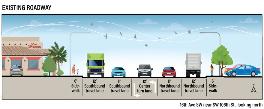
The image above shows what 16th Avenue SW between SW 100th and SW 107th streets looked like before the project began. The road had two travel lanes in each direction and a center turn lane. There are no bicycle lanes on this road. View larger image (55KB)
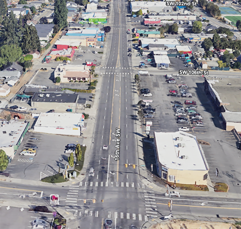
Google Earth photo of 16th Ave. SW between SW 107th and SW 102nd streets looking north (photo taken in 2022). The existing road layout is built more for car traffic than people walking or biking.
Project budget and funding
The total estimated project cost is $1.9 million. This project has been awarded $1,752,200 in federal Highway Safety Improvement Program funding.
Community involvement
Early project design - Winter and spring 2022
The county worked with community members, businesses, and residents throughout the project. We joined community meetings and White Center events and also ran two major outreach campaigns. We conducted two online surveys—one early in the design process and another at the final stage.
King County conducted an outreach campaign and survey to collect input from over 800 community members. Two potential project design options were presented to the community for their consideration.
- Design option 1:
- One travel lane in each direction and a center turn lane
- Dedicated lanes for bicycles in both directions.
- No change to on-street parking. Same number of existing parking spaces (46 spaces).
- Design option 2:
- One travel lane in each direction and a center turn lane
- No dedicated lanes for bicycles.
- Adds more street parking on both sides of the road.
Over half of the survey participants chose Design option 1 as the best fit for the community’s needs. As a result, the County proceeded with this chosen design.
Late project design – Summer 2024
We held a community outreach meeting on July 24, 2024, and conducted a survey in July and August 2024. Slightly more than half of the 806 responses supported including bike lanes in both directions, along with other pedestrian safety and traffic calming measures included in the final design.
- Contact us for survey results, or if you would like a copy of the 2024 community meeting presentation.
Why the county decided to include bike lanes
Our goal is to help everyone, including people who need extra time in the crosswalk, to get across the road safely. We added bike lanes along with curb extensions and bright yellow flashing signs to help slow down traffic and protect people from the danger of getting hit by a moving vehicle.
Our decision-making process focused on saving lives and listening to what the community had to say. We also paid attention to concerns about parking, especially from businesses in downtown White Center.
During the early design phase in winter and spring 2022, we gave the community two options. One included bike lanes and about the same amount of parking as now. The other option had more parking but no bike lanes. Both options got almost the same level of support, but more people said they wanted bike lanes. Because of this, and advice from traffic safety experts, we decided to add bike lanes to the project.
In July and August 2024, the project design was nearly finished. We held another project survey to make sure residents, workers, and business owners were aware of the project, and to see if our decision to include bike lanes still met the needs of the community. The feedback showed that just over half supported bike lanes in both directions. This matched what we heard in 2022.
While surveys give us helpful information, they aren't always perfect. Since our main goal is to keep everyone safe, and bike lanes have been shown to reduce accidents and make traffic flow better, we decided to move forward with the current design that includes bike lanes.
What we heard
There is strong support for slowing traffic and making this busy road safer for everyone—drivers, pedestrians, cyclists, and scooter riders. Additionally, residents expressed the need for more on-street parking, especially in front of businesses without parking lots.
Concerns were also raised about ensuring long-standing residents and businesses maintain a strong sense of belonging in the area.
What we are doing
This project gives us an opportunity to make 16th Avenue SW safer for everyone. The county has decided to proceed with the current design, which includes bike lanes.
Bike lanes, along with the other pedestrian safety improvements, help reduce the chances of accidents between vehicles and people on foot, bicycle or scooter. Bike lanes also keep bicycles off the main road, which helps traffic flow more smoothly and safely.
Frequently asked questions
- Countdown pedestrian signal heads will let pedestrians know how much time remains to cross the intersection
- Audible messaging will inform pedestrians which crossing has a “walk”
- Vibration and tactile surfaces at crosswalks and intersections will also inform pedestrians which crossing has a “walk”
- High visibility pedestrian safety signs make it easier for drivers to know when to expect pedestrians
- Accessible ramps help people with disabilities, people pushing strollers, and others, access the crosswalk
Weekend work is possible if we need to make up time due to rain or equipment problems. If that happens, we’ll let the community know ahead of time.
Photos

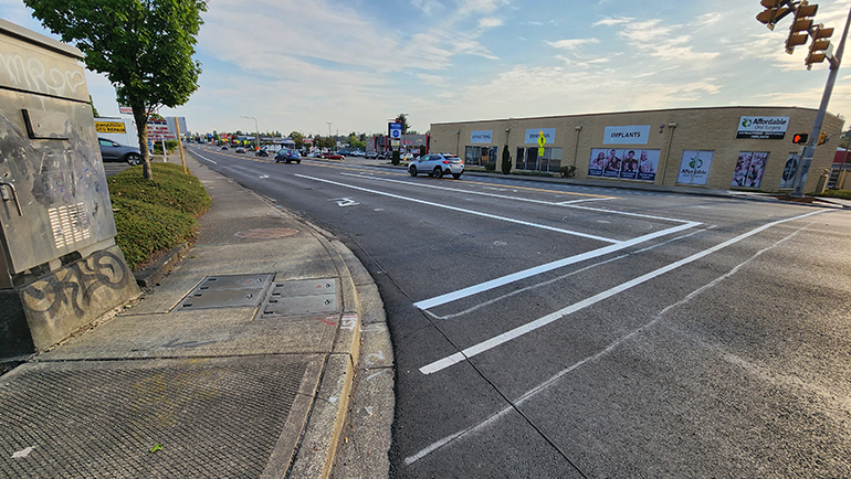
January 2026: Contractor crews working for King County built curb extensions at the corner of 16th Ave SW and SW 106th St to make it safer for pedestrians to cross the road.
August 2025: Looking north at 16th Avenue SW and SW 107th Street, there is new fresh and smooth pavement on the road. Crews returned in January 2026 to add additional pedestrian and bicycle safety improvements on 16th Avenue SW between SW 100th and 107th Streets.
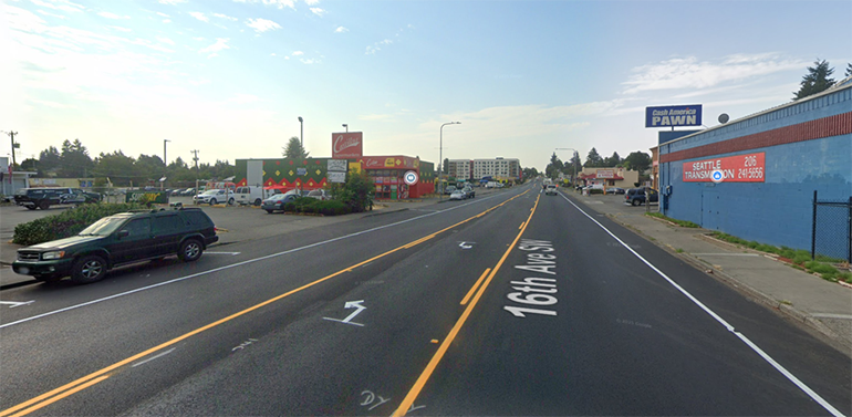
August 2025: The new travel lanes have been striped with temporary tape. 16th Avenue SW has one northbound and one southbound travel lane with a center turn lane. Image from Google Maps.
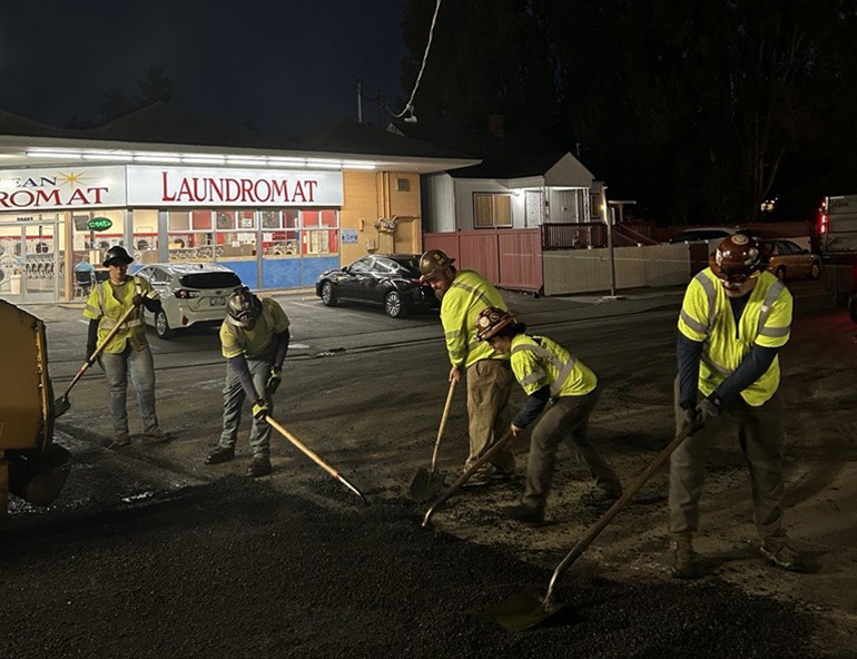
July 2025: Crews contracted by King County Road Services worked throughout the night to lessen traffic impacts to the area.

April 2025 – Crews completed the second phase of the drainage improvement project, which required a closure at the intersection of SW 104th St and 16th Ave SW.

March 2025 – Crews use heavy machinery to replace the old pipe under SW 104th Street and 16th Avenue SW. The blue box shown in the middle of the photo stabilizes the work site, preventing the ground from collapsing during the process. This intersection was closed to traffic for 18 days in March 2025 to replace the pipe.