
 Translate
Landslide mapping
Information on current landslide and steep slope mapping, information, and resources.
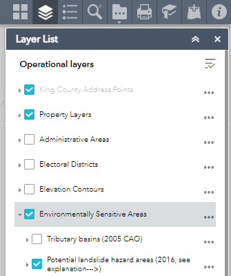
The potential landslide hazard areas map identifies areas that have been categorized as potential landslide hazard areas. The map does not purport to identify actual landslide hazards or existing landslide risks for specific properties. Depending on the nature of any proposed development, further investigation of the site and a detailed evaluation of the landslide hazard by a licensed geological engineer may be recommended.
Map access
To view this map, go to the King County iMap website, once you launch the application, go to the top right corner and select "layer list", then select "Environmentally Sensitive Areas".
Additional information and services
Additional information and mapping can be found on the King County water and land services website, such as:
- Types of landslides
- Floodplain maps
- Potential landslide hazard areas along the river valley walls and floodplains
- Mapping methodologies information
- Channel migration hazards