Monitoring: How are Miller and Walker Creeks doing?
The Miller and Walker Creeks Monitoring Sampling and Analysis Program provides information about
- the health of the lands and waters of the Miller and Walker Creeks basin
- water quantity, water quality, habitat, and salmon populations
- effects of restoration actions, stormwater management, and land use
Health conditions
The Community Salmon Investigation has collected adult salmon data since 2010. Volunteer teams survey portions of Miller and Walker Creeks every day, October through December. They count the number of live adult salmon in the creeks. They measure and dissect salmon carcasses to determine how many fish were able to spawn.
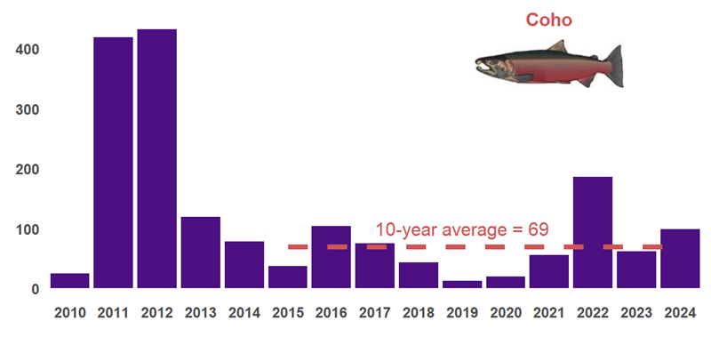
Number of live adult coho salmon observed in Miller and Walker Creeks (2010-2024).
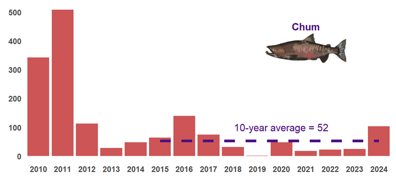
Number of live adult chum salmon observed in Miller and Walker Creeks (2010-2024).
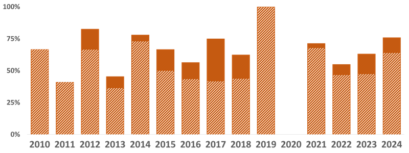
Percentage of adult female coho with observed pre-spawn mortality in Miller and Walker Creeks (2010-2024). Patterned bars indicate mortality without observable predation marks.
Sign up to volunteer for the Community Salmon Investigation!
Stream bugs are one of the best ways to track stream health. They respond to changes in water quality and habitat conditions. The number and types of bugs found in a stream indicate how healthy the stream is.
Every year, King County scientists sample stream bugs (also known as benthic macroinvertebrates) at 170+ stream sites, including sites in Miller and Walker Creeks. Learn more about King County's Benthic Macroinvertebrate Ambient Monitoring Program.
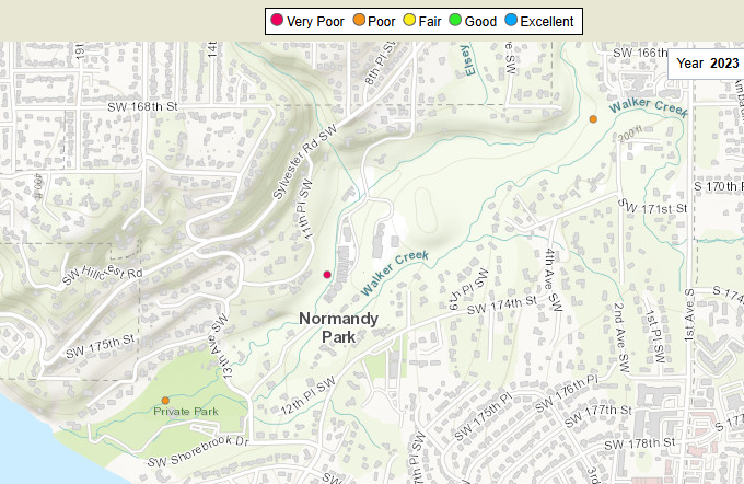
Map showing two Miller Creek sites and one Walker Creek site. Each site dot is colored with a stream health score calculated from stream bugs sampled in Fall 2023.
Noxious weeds are weeds that are harmful to public health, agriculture, recreation, wildlife, or property. Noxious weeds affect the ecology of streams by altering riparian (streamside) vegetation. They can outcompete, harm, or prevent native plant growth. They can increase erosion and destroy wildlife habitat. Stopping the spread of noxious weeds, removing them from streamside habitats, and planting native PNW plants can help make the creeks healthier.
The King County Noxious Weed Control Program surveys areas throughout the Miller and Walker Creeks basin annually to track what noxious weeds are observed where. They provide education and technical assistance to landowners and public agencies to help everyone find the best removal and control options for noxious weeds.
You can explore noxious weed locations near Miller and Walker Creeks on King County iMap. Open King County iMap and add the Noxious Weeds layer. Zoom in to show the weed locations and click on the legend button to see weed names.

Screenshot of noxious weed locations within the Miller and Walker Creeks basin mapped in 2024.
There are several active stream gages on Miller and Walker Creeks that measure and record stream flow, precipitation, water temperature, and water quality.
To see all stream gage locations and download gage data, visit the King County Hydrologic Information Center Station Map.
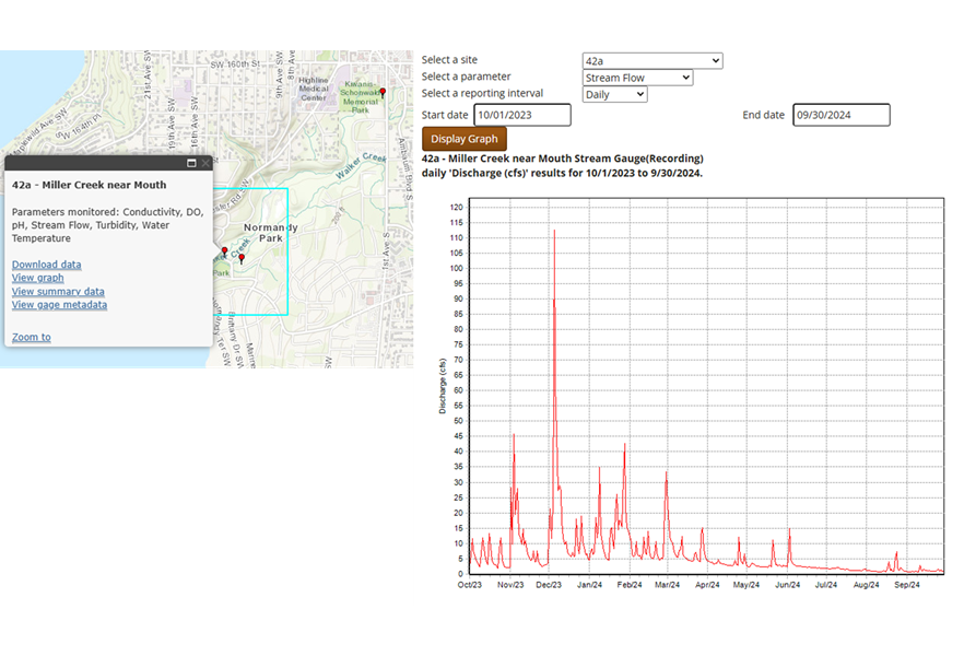
Daily stream flow measurements from the gage station near the mouth of Miller Creek from October 2023 through September 2024.
Stewardship of the Miller and Walker Creeks basin is jointly funded by the City of Burien, City of Normandy Park, City of SeaTac, King County, and the Port of Seattle. On behalf of the partners, this page is proudly hosted by King County Department of Natural Resources and Parks - Water and Land Resources Division.
.png?rev=0f500b44fc6e40b78a46781d20500600&hash=9BABA41389AB8DB390B590B87207972C)
 Translate