
 Translate
NE 165th Street water over the roadway
NE 165th Street between 183rd Place NE and 179th Place NE

June 16, 2026: persistent standing water is still present in mid-June covering both directions of NE 165th Street.
Status update
June 2026
NE 165th Street is routinely checked by Road Services crew members to check whether water has receded from the travel lanes and to assess if standing water has damaged the road’s substructure.
In late 2025, survey crews collected road surface measurements to help us monitor conditions on NE 165th St. Road Services will continue gathering data to better understand the changes to the roadway. Geotechnical boring (gathering soil samples to determine the road’s current structural integrity) occurred on Monday, March 23, 2026. A summary of the results of the geotechnical boring is below on the website.
Overview
In the past, NE 165th Street between 183rd Place NE and 179th Place NE would flood during heavy rain, and we would close it due to water over the roadway to keep drivers safe. Once the water went down and there was no water in the driving lanes, we reopened it.
But now, the water hasn’t gone away like it used to. The road has been under water for a long time, and we also need to check if the ground underneath is still stable before we can safely reopen it.
We don’t close roads unless it is a safety issue. With over 1,500 miles of roads to take care of, safety is always our top priority. Even if the water goes away, the road might still be damaged and unsafe to drive on.
We can’t fix the road until we find a solution that keeps people safe and protects the environment.
This area is very environmentally sensitive. It’s built on a peat bog and surrounded by wetlands, a floodplain, and a stream. It’s also part of a protected area that helps keep drinking water clean. Because of this, there are many rules we must follow before doing any work here.
Fixing the road could harm the environment, cause flooding nearby, and would cost more than we can afford right now.
Why is it unsafe to drive through water on the road?
It is unsafe to drive through water on the road because it can cause your car to stall, become uncontrollable, or be swept away, while also hiding unseen dangers. Water can damage your vehicle's engine and electrical systems, and even a small amount of moving water is powerful enough to carry away most vehicles. The road surface beneath the water may be washed out or damaged, and the water itself can hide debris, downed power lines, or open manholes.
Loss of control and vehicle submersion
- Hydroplaning: Water causes your tires to lose contact with the road surface. This can make your car uncontrollable, especially at higher speeds, and can lead to collisions.
- Car floatation: As little as two inches of water can be enough to lift and float most cars, making them uncontrollable. Two feet of rushing water can carry away most SUVs and trucks.
- Reduced friction: Water reduces the friction between your tires and the road, making it harder to steer and brake.
Hidden hazards
- Washed-out roads: Water can erode the roadbed, creating hidden dips, potholes, or even completely washed-out sections that your car could fall into.
- Submerged objects: The water can conceal dangerous debris, open manholes, downed electrical lines, or other hazards.
- Unknown water depth: You cannot accurately judge the depth of the water, which may be much deeper than it appears.
Vehicle damage
- Engine and transmission damage: Water can get into your engine's air intake or exhaust, causing a condition called hydro locking, which can lead to catastrophic engine and transmission damage.
- Electrical system failure: Driving through water can short-circuit your car's electrical components, leading to a complete failure of systems like the dashboard, airbags, and anti-lock brakes.
- Corrosion: Prolonged exposure to water can cause parts to corrode, leading to long-term issues such as electrical faults and mold growth.
Geotechnical summary
The section of NE 165th Street between 179th Pl NE and 183rd Pl NE sits on top of soft, wetland soil made mostly of peat (spongy material formed by decaying plant matter) and organic silt. This type of soil holds a lot of water and sinks, shifts, and slowly flattens under pressure over time. This causes roads to settle unevenly, creating cracks, dips, and instability. That’s why King County keeps a close eye on how this corridor is performing.
The county drilled small test holes in 2016 and again in 2025 to collect soil samples and see whether the roadway had settled or changed over time. In most areas, the road sank less than half an inch over the ten-year period. Overall, the road is experiencing minor, even settling (0.5 inch) with a few areas dipping a bit more than others, to about 1.2 inches.
These results match what engineers expect in peat. Today, the soil is reaching a stable state, meaning most of the big changes have already happened. While the road has sunk about 6.5 inches since it was built, engineers estimate it will continue to gradually settle.
King County will continue monitoring the area.
What is a peat bog?
A peat bog is a special kind of wetland. Peat forms in places where the ground stays very wet all the time. In these soggy areas, dead plants, especially a type of moss called sphagnum moss don’t fully break down. Instead, they slowly pile up and turn into a thick, dark material called peat. This process takes thousands of years.
How do peat bogs form?
Peat bogs often start in low, swampy areas or old lakes left behind by melting glaciers. Plants grow, die, and fall into the water. But because the ground is so wet and has little oxygen, the plants don’t rot like they normally would. Over time, layers of peat build up.
Why are peat bogs important?
Peat bogs are great at storing carbon, which helps fight climate change. They trap carbon that would otherwise go into the air as carbon dioxide. They also provide homes for rare plants and animals and help supply clean drinking water.
What is the Basset Pond Natural Area?
Bassett Pond Natural Area is an important place for nature in our region. It helps keep the environment healthy by soaking up rainwater, preventing floods, and cleaning dirty water before it flows into bigger rivers or lakes. The pond and nearby trees and plants are home to many animals like birds, frogs, and insects. It also helps clean the air and keep the area cooler, which is good for both people and wildlife.
This area is also very sensitive, which means it can be easily harmed. Wetlands like Bassett Pond take a long time to heal if they are damaged by pollution, too much foot traffic, or nearby construction. Even small changes can hurt the animals that live there or make the water dirty. That’s why it’s important to protect this space, so it can keep doing its job and remain a safe place for plants, animals, and people to enjoy.
What makes this area environmentally sensitive?
NE 165th Street corridor lies within a highly sensitive ecological area, including the Bassett Natural Area, a stream, a wetland, a floodplain, and a Critical Aquifer Recharge Area (CARA). Critical aquifer recharge areas are defined as regions with a significant recharging effect on aquifers used for drinking water. These areas are crucial for maintaining groundwater supplies, especially in regions where surface water is limited. The Washington Administrative Code (WAC) defines CARAs as areas that contribute significantly to the replenishment of groundwater and are vulnerable to contamination. This area also provides habitat for federally threatened steelhead trout and Chinook salmon, along with other native fish species.
Environmental agencies that may need to be involved to work in this environmentally sensitive area.
Any flood reduction or road restoration must meet extensive environmental regulations, potentially requiring review under:
- The National Environmental Policy Act (NEPA)
- State Environmental Policy Act (SEPA)
- Section 404 of the Clean Water Act
- Hydraulic Project Approval from the Washington Department of Fish and Wildlife (WDFW)
- U.S. Army Corps of Engineers
- Biological Assessment (BA) for Endangered Species Act (ESA)
King County may also require:
- Clearing and Grading Permit
- Flood Hazard Certification
- Shoreline Substantial Development Permit
- Critical Areas Alteration Exception
We might also need to add extra space for floodwater and improve the wetlands. Once we pick a solution, we’ll need to perform engineering analysis and check for any important cultural or historical sites.
These requirements reflect the complexity of restoring infrastructure in this environmentally sensitive area.
Location map

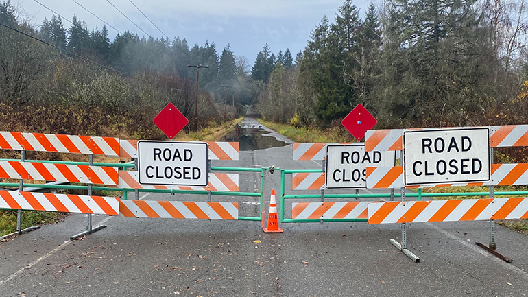
In the Cottage Lake community, NE 165th Street is closed to all traffic between 179th Place NE and 183rd Place NE.
Frequently asked questions
NE 165th Street will remain closed while standing water is on the roadway. Once the water has receded staff will inspect the roadway to make sure that the integrity of the road is safe for the traveling public before opening the road.
Closing a road in unincorporated King County on any of our 1,500 miles of maintained road network is not taken lightly but is done for the safety of the public.
King County Road Services installed permanent gates on NE 165th Street between 183rd Place NE and 179th Place NE, to be used when the road is closed due to water in the traveling lanes. The gate prevents drivers from using this section of road when standing water is present and for public safety.
Previously, lightweight barricades were used, but they were often moved by drivers who ignored the closure. This unintentionally allowed others to drive through unsafe conditions before the road was safe to reopen. This has resulted in vehicles stalling in the standing water and created a life safety concern.
Repairing this road is extremely complicated. Many permits are required from federal, state and local agencies to approve work in this environmentally sensitive area.
The County Flood Code requires the development of compensatory storage to ensure that a new location for flood water is available to offset the lost storage capacity caused by the road-raising material. While the County identified candidate sites on Department of Natural Resources and Parks (DNRP) property, they would require costly upgrades to DNRP facilities and are not financially feasible.
Road Services designed a project to reduce the frequency and duration of flooding by raising the roadway surface elevation with a thicker layer of asphalt over the existing road base. The design included geosynthetic wraps to help distribute the weight of the new asphalt, and culverts to connect wetlands. The project has not been implemented due to flooding and environmental regulations and their associated costs.
A bridge has also been considered which would eliminate all flooding, however it is too costly to move to the design phase.
There is no timeline for a fix to reopen NE 165th Street. If there are changes to the road closure, community members will be informed in the following ways:
- This website will be updated with current information
- MyCommute listing will be updated
- A Road Alert will be sent to those who have subscribed to that service
King County Road Services has investigated traffic safety concerns. Below are nearby traffic safety investigations and outcomes:
| Location | Investigation and Outcome |
|
177th Place NE |
|
| NE 160th Street/NE 159th Street |
NE 159th Street: (locations are near the cross streets listed below) speed limit and volume counts occurred:
Rotational Radar Speed Signs were installed in December 2024:
Orange Flags were added to ‘Stop Ahead’ warning signs and installed March 2025:
|
| NE 165th Street near 177th Place NE |
Speed limit and volume counts occurred in October 2025:
|
| 177th Place NE/NE 160th Place/NE 160th Street/NE 159th Street – NE 165th Street to Avondale Road NE | Centerline reflective pavement marker replacement |
| NE 155th Street/NE 156th Street – 175th Avenue NE to Avondale Road NE | Centerline reflective pavement marker replacement |
| NE 159th Street: 4 locations between 183rd Place NE and Avondale Road NE | 25 mph speed limit painted on the roadway |
| NE 160th Place: 1 location between 177th Place NE and 179th Place NE | 25 mph speed limit painted on the roadway |
| 177th Place NE: 1 location between NE 160th Place and NE 165th Street | 25 mph speed limit painted on the roadway |
| NE 155th Street: 2 locations between 188th Avenue NE and Avondale Road NE | 25 mph speed limit painted on the roadway |
| NE 156th Street: 3 locations between 180th Place NE and 185th Avenue NE | 25 mph speed limit painted on the roadway |
| Avondale Road NE and NE 159th Street | Reviewed in May 2024 for signal warrant/parameters. Conditions for a signal were not met. |
Road improvements in unincorporated King County are guided by the King County Road Design and Construction Standards, which are part of the King County Code. These standards recommend a roadside shoulder width of four to eight feet on the side of rural neighborhood roads. These standards also state that ‘shoulder’ type improvements for non-motorized users, such as people walking or biking, are appropriate for rural areas outside of urban growth boundaries like the neighborhood roads surrounding NE 165th Street.
The King County Road Design and Construction Standards were last updated in 2016. It is not possible to upgrade the entire county road network to meet these standards when the standards are updated. For example, the physical constraints on NE 159th Street would require a major capital project to widen the road. King County has a structural funding gap for roads and current funding levels for county roads and bridges are sufficient only to address critical life safety issues and a minor amount of work to preserve or replace some of the existing infrastructure.
The county has not installed a speed bump since the early 2000s and no longer installs them. Roads with speed bumps are outside of unincorporated King County, on private roads, or the speed bumps were installed back when the county did install speed bumps.
Speed bumps have negative consequences that deter the county from installing them. They hinder the response time of emergency vehicles, can cause damage to vehicles, and can contribute to neighborhood noise pollution. Also, we found some drivers tend to increase vehicle speeds between speed bumps compared to speeds before the speed bumps were installed. For these reasons, the county does not install them, nor do we permit others to install or maintain them in the public right-of-way.
We have collaborated with the King County Sherriff’s Office. They are aware of the closure and receive the communities’ reports about speeding. The NE 165th Street community is on a continuous list to patrol when the officers can schedule enforcement after their prioritized workload.
The King County Sheriff’s Office is the only agency authorized to enforce speed limits in unincorporated King County. You may request enforcement by calling the non-emergency line at 206-296-3311 or report it online at Traffic Complaint Reporting - King County, Washington. It is also helpful to share times of the day when you observe speeding.
Photos

April 6, 2026: Water remains covering the east and most of the west bound travel lanes on NE 16th St. This road will remain closed to keep travelers safe.
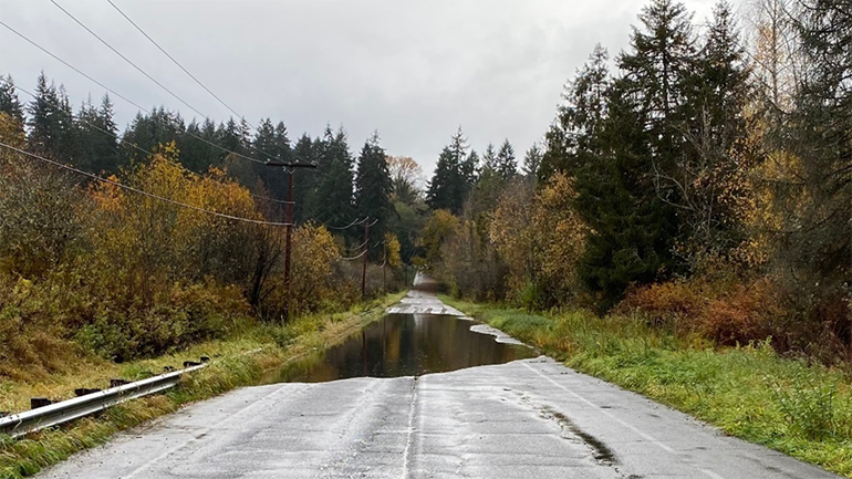
March 9, 2026: Water covers the east and much of the west bound travel lanes on NE 165th Street.
December 2, 2025: Water covers both the east and west bound travel lanes on NE 165th Street requiring the road to remain closed.
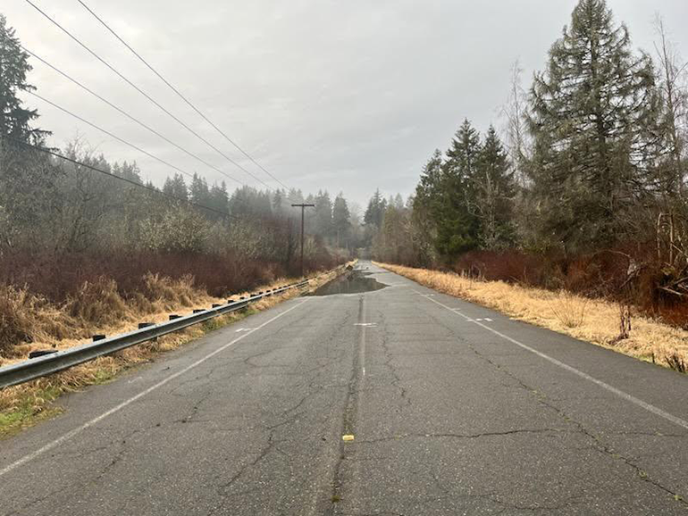
November 6, 2025: looking west, water covers both lanes of NE 165th Street making it unsafe for any travel. Water that sits on the road for an extended period can impact the substructure of the road making it unsafe for travel even if the road was dry.

October 28, 2025: Looking eastbound from NE 179th Place at the gate on NE 165th Street, water can be seen over the roadway. It is not safe for vehicles to travel through standing water.