
 Translate
King County Flood Management Plan
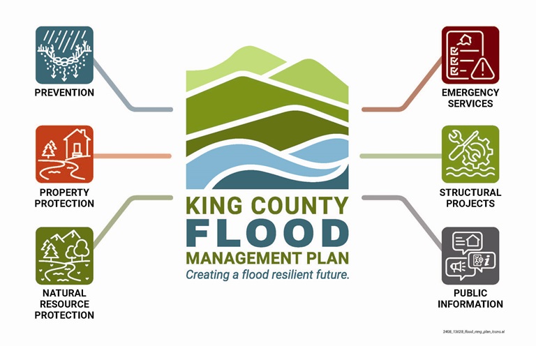
The 2024 King County Flood Management Plan outlines a vision for reducing flood and flood-related risks countywide. It describes the actions King County will take to manage risks associated with flooding along our rivers, creeks, and shorelines, including opportunities for the County to work with cities, partners, and community members to build flood resilience.
The 2024 Flood Plan was proposed by Executive Constantine to the Metropolitan King County Council in June 2024 and adopted by the Council on September 17, 2024.
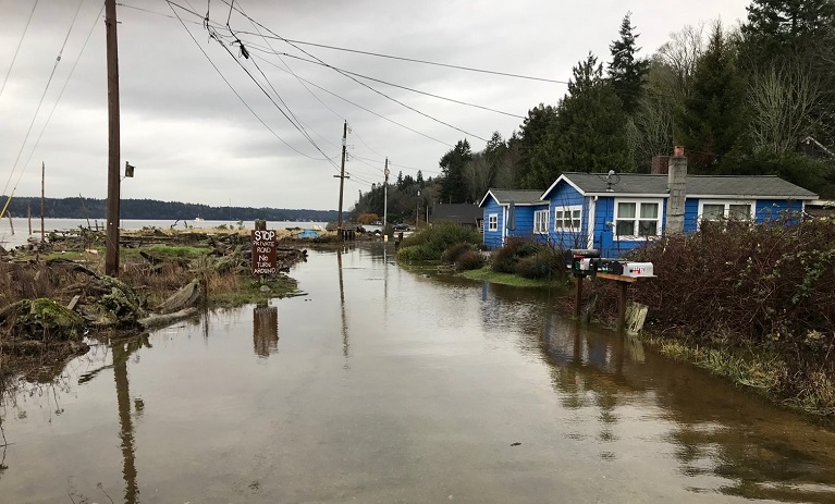
Flooding is King County’s most common and costliest natural disaster. Since 1956, King County has experienced 29 presidentially declared flooding disasters, and smaller flood events occur with regularity. King County last updated the flood plan in 2013. In the time since, flood events have changed how our rivers and waterways look and function. Our population has grown, and we’ve added more homes and businesses to the landscape. Climate change is increasing the likelihood of larger and more frequent flooding, including flooding in places that have not historically flooded. In addition to evolving flood risks, we now have more experience with implementing actions that reduce those risks while also providing other community and environmental benefits.
Community engagement
King County solicited public comments on the Draft Flood Plan and associated Draft Environmental Impact Statement in 2024.
During the comment period, King County hosted two online public meetings in early 2024. Visit the King County Engagement Hub to view the presentations and videos from those meetings and a public comment summary.
The plan was developed by seeking out and incorporating the diverse perspectives of our community. This plan also reflects a broader range of flooding types than King County’s past flood plans. In addition to mainstem rivers, new areas of emphasis include coastal flood hazards and sea level rise, small stream flooding, and urban flooding.
By proposing new policies and many different projects and programs, the 2024 Flood Plan intends to reduce risk to people and property from flooding and channel migration while also supporting resilient communities and ecosystems. The plan will guide King County's work, set county policy for floodplain management, and will help to guide county investments that reduce flood risk and deliver multiple community benefits. The plan meets federal requirements for the National Flood Insurance Program, and it’s hoped that other local governments look to this plan as a resource as they implement their own flood risk reduction activities.
Links and resources
2024 King County Flood Management Plan
Acknowledgments, Executive Summary, Table of Contents
Chapter 2, Flooding in King County
Chapter 3, Review of Flood Risk Reduction Activities
Chapter 4, Comprehensive Risk Mitigation Strategy and Action Plan
Chapter 5, Plan Implementation
Chapter 6, References and Source Material
2024 King County Flood Management Plan Appendices
State Environmental Policy Act (SEPA)
2024 King County Flood Management Plan SEPA Final Programmatic Environmental Impact Statement
Partner Planning Committee
The Partner Planning Committee helped shape the flood plan through in-depth discussions at 10 meetings over 16 months.
Partner Planning Committee information
Past flood plans
The most recent flood plan was completed in 2006 and adopted by King County Council in January 2007. The flood plan was last updated in 2013 and adopted by King County Council with the passage of Ordinance No. 2013-0419.
Download the 2006 flood plan and 2013 flood plan update. These reports are provided in Adobe Acrobat .pdf format.
2006 King County Flood Hazard Management Plan (16.6 MB)
2013 King County Flood Hazard Management Plan Update and Progress Report (4 MB)
Printed copies of the 2006 flood plan, 2013 flood plan update are available at the following King County libraries:
- Auburn Library
- Bellevue Regional Library
- Bothell Regional Library
- Carnation Library
- Duvall Library
- Fairwood Library
- Fall City Library
- Issaquah Library
- Kent Library
- Maple Valley Library
- Muckleshoot Library
- North Bend Library
- Redmond Regional Library
- Skykomish Library
- Snoqualmie Library
- Tukwila Library